Cumnock Places

The Brigs of Cumnock – Passing over and under places

In Cumnock there are several places we cross over most days but pay scant attention to them – unless they are impassable or flooded. There are over 16 brigs throughout Cumnock which span both the Lugar and the Glaisnock waters. They help up get about and in and out of town – each has its own story. You can view a presentation of this HERE

On the Lugar Water

A one-span County Brig built over the river Lugar on the Logan Estate at Holmhead Farm. Built in the 18th Century and replaced in the 1960s with a new modern bridge slightly downstream. The old brig continues to be used as a footpath from Logan to Lugar.

The original Rifleman’s Bridge was very old and built in 1800s. It spanned 75 feet over Lugar Water upstream from the Templand Viaduct and Mote Hill in the Lugar Glen. It was near a favourite picnic spot which was popular throughout the 1940s to the 1960s.

The story of the brig is told in a Cumnock Chronicle article from 1904
“In our younger days the Rifleman’s Brig marked a picturesque spot on the Lugar just beneath the target. It was a wooden brig, and a rather shaky one, but it was guarded by a gate in a palisade that was unclimbable. Once upon a time it could be climbed but the riflemen, rather meanly as we boys thought, added to the height of this palisade affair and also widened it until the edges were too far out to be negotiated without grave risk of dropping fifteen or twenty feet into the river. Around the edges and along the top there bristled a row of the most evil looking nails one might wish to see, so that the bravest preferred to cross to the other side through the river bed. But as the old giveth place to the new, so this ancient structure gave place to an elegant suspension brig erected further up the river and at a more convenient point for those who had a lawful right to use it. The new bridge was left open for the use of the public and the public did not use it well. The unthinking portion ‘swung’ the brig for the fun of the thing until it began to show signs of abuse. It gradually got worse and worse until the Volunteers were compelled to go to the expense of erecting a new one. It has been designed by Robert Bowie CE of Lugar and built on the lattice girder principle by McCartney and Co, Cumnock who have secured the contract. The building of the necessary piers has been awarded to ex-Provost Richmond’s building company.”

McCartney’s Engineering was under the control of the Taylor brothers, Charles and Andrew. The name Rifleman’s Bridge stems from the fact that the bridge was once used by Cumnock Territorial Volunteer Army Corps for rifle practice. The Volunteers were keen shots and also had a rifle range and target nearby. The Rifleman’s Brig was removed around 1927 when the landowners decided to remove it. It was offered to Cumnock Town Council but after various plans to use parts of the bridge to replace Joe’s Brig in Cumnock the plans were dropped due to the brig being rivetted together and difficult to remove. Parts of the concrete piers are all that remains today.

Templand or Lugar Viaduct was one of the great engineering feats on the Glasgow, Paisley, Kilmarnock and Ayr line, which opened on 20th May 1850. It consists of 13 arches – the highest being 175 feet above the Lugar Water. The engineer was John Miller of the firm Miller and Grainger of Edinburgh. The viaduct – which takes its name from nearby Templand Farm – is still used by the Glasgow to Dumfries railway.

Spans the Lugar Water downstream from the Templand Viaduct and connects the Bank with Woodroad Park. Built in 1930s to allow easy access to the swimming pool and recreation facilities at the Woodroad.

Spans the Lugar Water and connects Warrick Drive in the Glebe with the Woodroad Park. Built by Tubewrights Ltd in Monmouthshire, Wales. Built in 1936 as part of the redevelopment of the Woodroad Park to allow easier access to the swimming pool and other park attractions.

The original Stepends Ford was bridged over in 1753 by a two-span brig which caused a serious accident in which 4 men and 3 boys were killed when an arch collapsed.

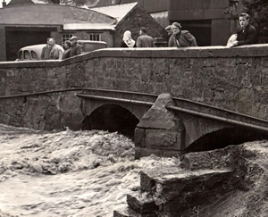
The present brig spanning the Lugar Water at the Congregational Church on Auchinleck Road went out to tender in April 1861 and is built in red sandstone with a single span of 64 feet. Contractors were A Gibson of Auchinleck and A Murdoch of Cumnock. There was a temporary wooden brig built as the old brig was taken down but the heavy storms in August and September of that year washed away the wooden brig, parts of the new stone brig and dislodged the crane that was being used in the construction. After a further accident with the arch partially collapsing, the new brig finally opened in 1864. It was widened in 2006 to accommodate a wider road and two pavements.

From Warrick’s the History of Old Cumnock 1899
In the year 1753 a bridge was thrown over the Lugar at Stepends. In all likelihood, it was the first which was built. It met, however, with an untimely end, and brought sudden death to a number of workmen engaged in its construction. The incident is told in the Scots Magazine of that year. “On the 8th August several workmen employed in building a bridge over the Lugar at Cumnock in the shire of Air, in order to shelter themselves from a heavy shower of rain, went in under a new finished arch from which the cumb or timber arch had been taken away the day before. All of a sudden, the arch fell; by which four men and four boys were killed, three had their legs broken, several others were hurt, and a horse was killed. This is thought to have been occasioned by the arch being too low. It was fifty-five feet wide and had but eight feet of spring.” It is somewhat singular that when the present bridge was being constructed over the Lugar at the same place, an accident of a similar nature took place, though happily without loss of life.

Spans the Glaisnock Water at the Dubb where the Glaisnock and the Lugar Waters meet. The original old stone brig had two spans and was about a third of the width of the present bridge. Widened in 1963 as part of the Tanyard demolition, some parts of the old brig still remain on the Dubb side if you look closely enough. New Bridge Street took its name from it.

Replaced an old Ford at the western end of the mill-race at Greenmill. Spans the Lugar Water and connects Cumnock Academy with Broomfield. Built in the 1960s to allow easy access to Broomfield playing fields by academy pupils, the brig is soon to be replaced as part of the Barony Learning Campus proposals.

On Glaisnock Water

Spans the Glaisnock Water downstream of Glaisnock Viaduct just behind Wylie Crescent and is part of the Glaisnock Water riverside walk. Built in 1990s.

Taken from Murray Park by Bobby Grierson December 2015

Greenholm brig spans the Glaisnock Water and connects Greenholm Road and Townhead Street at the Asda Car Park and was built in the 1940s. Built by Tubewrights Ltd in Monmouthshire, Wales. The firm was established in 1939 as a subsidiary of steel tube makers Stewarts & Lloyds. It was about 20 feet upstream of Joe’s Brig and was upgraded in 2014.

Built to replace the old stepping-stone ford at Greenholm just downstream from the present Greenholm Brig at Asda.

Joe Hunter, a Potter at Cumnock Pottery in Glaisnock Street first petitioned the Town Council to build a bridge at Greenholm to replace the Stepping Stone Ford in 1909. Joe and his family lived at 112 Townhead Street and he regularly used the Stepping Stones as a short cut to work but as he had fallen in on one occasion and traffic was increasing over the ford, he kept up his request to the council. By 1914 his representations to the council bore fruit and they agreed to hold a count of how many people crossed the ford in a single day. The number was over 500 so Joe’s persistence paid off and the council agreed to build the bridge. The bridge was described in the Cumnock Chronicle as “Situated about 20 feet further up the Glaisnock Water than the Stepping Stones, the bridge is rustic in design and in addition to its usefulness as a footway is a most artistic landmark. It is built on three strong concrete piers reinforced with ironwork structure. The wood is larch throughout and all locally grown. The foundation consists of four stout trunks bolted to the piers while stout angle brackets and a firm bracework support another four trunks two feet higher up. Binding bolts three feet long secure the structure at various points. The rustic work along the sides, the wood for which was taken from Barshare, rises from the lower trunks to a height of five feet high. To minimise danger to children the inside of the rail-work has been wired. From end to end the bridge measures 45 feet and the footway is three feet wide. Concrete steps have been erected at either side and probably a simple fence will complete the pleasant effect and lessen the risk of pedestrians missing the entrance in the dark. The old stepping stones will be utilised as a breakwater for the central pier.”

The new brig then quickly became known as Joe’s Brig in honour of this tireless campaigner. This brig remained in constant use until 1927 when the now defunct Riflemans Brig was offered to the town council as a replacement. This was considered but not accepted. The wooden Joe’s Brig was now becoming unsafe and was replaced around 1930s with a brand-new metal brig which served the public until 1967 when it became dangerous and was taken down – the decision not to replace it was taken in the light of the Greenholm Brig being wider and newer. However, the brig was put into storage by the council then repaired and moved to span the Glaisnock Water at the new Ayr Road car park around 1973 and remained there until 1977 when it was replaced with the new Keir McTurk Brig which remains today.

Joe Hunter was born in 1855 in Coalsnaughton, Clackmannanshire. By the age of 16 he was working as an apprentice potter at the Portobello Pottery just outside Edinburgh. He married Janet Harper in 1883 at Portobello and by 1888 they had moved to Cumnock and he was working as a Potter at Cumnock Pottery. In 1911 Joe and his family were living at 112 Townhead Street.

Dec 2015 flood

Spans the Glaisnock Water and connects Greenholm Road and Townhead Street via Townhead Car Park. The present brig replaced an earlier wooden brig called the Timmer Brig which was washed away by a flood in 1898 then replaced and named Betty’s Brig after Betty Goldie or Goudie who was saved from drowning in that flood. Betty lived in the Can’le Hoos or Glaisnock Cottage – just next to the brig. Her home was invaded by the flood which had reached the ceiling of her house before local joiner James Davidson swam through the window and pulled Betty to safety. James was a direct descendant of Souter Johnnie of Robert Burns fame. Betty’s father was Sheriff Officer John Goldie who was involved in the infamous Cumnock Poaching Riot of 1833. Betty died in 1899.

The original Betty’s Brig was replaced by the present one in the 1970s but still retains the name.

Spanning the Glaisnock Water upstream of the Gorbals Brig, these two modern concrete brigs at the Glaisnock shopping centre were built in 1973 to allow easier access to the shops to and from Glaisnock Street. They are a popular meeting place for some of the older generation.

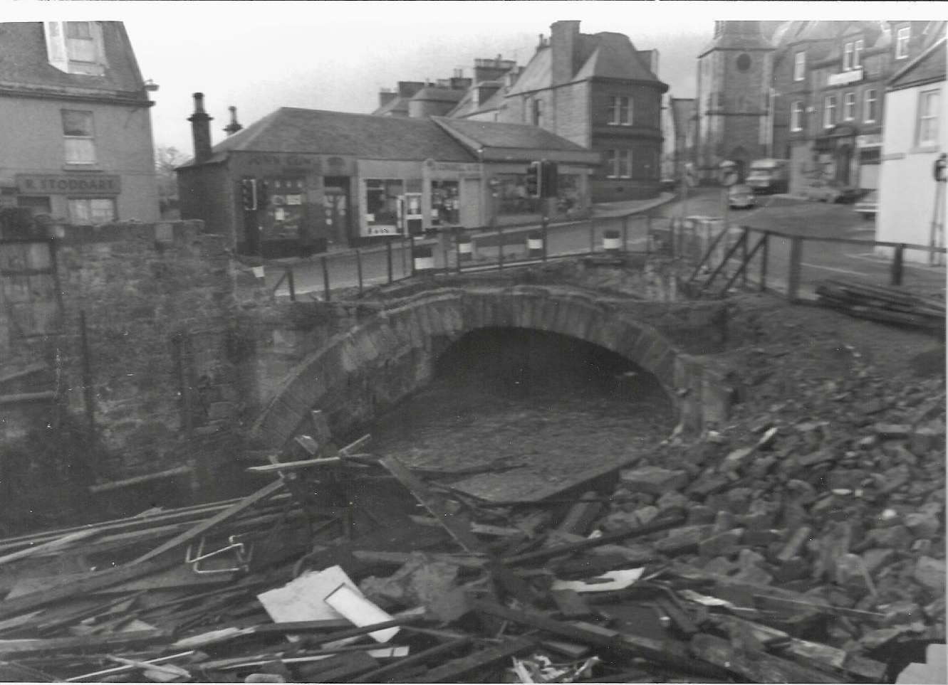
Spans the Glaisnock Water at Glaisnock Street and Tower Street, in a spot called the Gorbals. This wide brig also replaced an earlier one in the mid 1800s and is almost invisible as Glaisnock street passes straight over it and several shops are built over the west side. The brig was partially re-built, widened and strengthened in December 1977. The sandstone span can still be seen from the shopping precinct and the two smaller modern brigs, the Spittin’ Brigs just upstream.

Spans the Glaisnock Water and connects Ayr Road car park to the Tanyard. Replaced the re-used Joe’s Brig which was erected here around 1973 and then replaced in 1977 by the present brig which commemorates Keir McTurk, the 25th Provost of Cumnock.

Become a member

Membership to The Cumnock History Group is open to anyone with an interest in the history and heritage of Cumnock and its inhabitants.

Archive site
close slider

Visit archive site