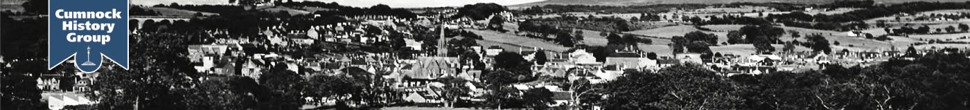
Streets
This is a work in progress. We need help about some streets, who/what it was named after, when it was built and any other interesting stories.
Please email with any information and/or photographs.
Armitage Drive was built in the early 1950's along with other streets in the area when the Town Council purchased the Shankston Bing site. Named after Dr William Armitage, a local doctor who served the local community from 1904 until he retired in 1947.
An old road to the neighbouring burgh of Auchinleck, which crosses the Lugar Water at Stepends Ford.
 Ayr Road is one of the main roads through the town and means literally the road to Ayr (the county town). Ayr Road leads of Glaisnock Street and was opened in the late 18th century, and in the early period there was a toll on the corner of Ayr Road and Glaisnock Street. Tolls were levied on goods and passengers coming into Cumnock.
Named after the hill to the south east of Cumnock.
Opened in 1969 the Cumnock Chronicle of 31st October 1969 says :-
Editor-publisher honoured in street naming
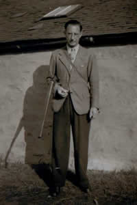
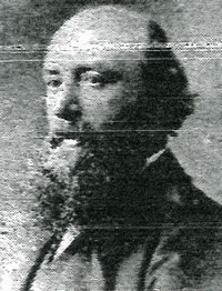
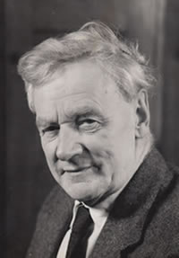
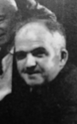
Mr D M Ballantine, editor-publisher of the Cumnock Chronicle since 1929, has joined the ranks of those Cumnockians who have been honoured by the Town Council in the naming of new streets. Asked by the Burgh Surveyor to select a name for a sub-section of the new Drumbrochan development, the councillors voted for Ballantine Court. The suggestion was made by ex-Provost J. K. H. McTurk, who spoke of the valuable link the Chronicle had provided over the years between the council and the public of the town.
Other names, which were considered for the new street, were Ellisland Avenue, Glaisnock Court, Roman Way, Linton Court, Drife Court, Logie Place, Hunter Court and Turner Terrace.
Mr Ballantine took over the editor-publisher role in 1929 from his father, the late James P. Ballantine. The family’s connection with Cumnock goes back to 1851, in which year the present editor’s grandfather established his printing business in the town.
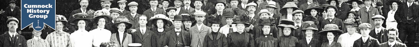
Duncan McClean Ballantine in the centre of photograph below.
Named after the steep bank leading down to the river Lugar.
An old lane to the west of the Square which connects Tower Street to Lugar Street. It is situated on the edge of a slope or bank.
Named after the steep bank leading down to the river Lugar.
Banfield Drive leaves Holmhead Road at right angles and goes east to meet with Oakbank Drive. It was named after Mr. Banfield, the architect who designed the houses for David King and son.
An old road leading from the north of the Square to Lugar and Muirkirk. Runs almost parallel with Townhead Street.
At the top of Barrhill Road before the road leaves town.
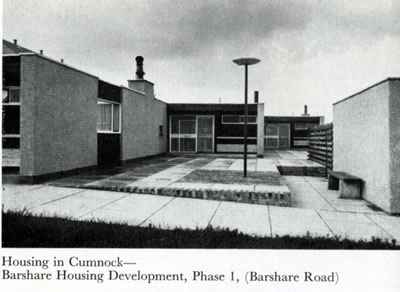
In 1957 the Town Council’s plans for a new housing scheme on the farmlands at Barshare was their most ambitious to date. They employed well-known architect Professor Robert Hogg Matthew to design and build a million pound scheme of 550 houses. The scheme and houses were cutting edge for the time with tiled under-floor heating, wide use of pine built-in storage, modern kitchens, open plan internal stairs with ultra modern rendering, street lighting and furniture.
Phase 1 of this development was completed by 1961 and 2 years later was awarded the prestigious Saltire Society Award for the best housing scheme in Scotland
The scheme continued to be expanded up until the 2000s.
To be completed.
The old narrow lane which lies behind the Mercat Hotel. It was named after the the old Black Bull Hotel - now the Mercat Hotel.
To be completed.
Named after Broomfield Park.
Named after Lord Bute.
A small close leading from the Square to Tower Street. Named after Cadam McClure who had a Confectioner and Tobacconists shop at 6 the Square.
To be completed.
To be completed.
To be completed.
Built in the 1960's as part of the Barshare housing scheme and named after local Dr A M Campbell who served the local community from 1929.
To be completed.
To be completed.
To be completed.
It is likely that Craighead Close - which runs to the right of the Craighead Inn - is the oldest surviving part of the town. The Craighead Inn dates from before 1722 when a lease was drawn up for the annual payment of £21 plus 2 hens and 2 loads of coal. It is supposed to have a ghost in the attic.
Where Crossriggs Veterinary Clinic is situated. An old part of town which stood at the end of Townhead Street.
To be completed.
Named after Craigens Farm.
Built in 1954 and named after William Dalgleish, a woollen manufacturer who was one of the the first Commissioners for the new Police Burgh of Cumnock. He was also the first Senior Police Magistrate from 1866-1878. The title Provost of Cumnock was then the official designation after 1892.
To be completed.
The twisting exit from Tower Street with a dog leg turn into Elbow lane and was likened to the Devil`s elbow.
To be completed.
Named after Drumbrochan Farm.
The Dubb Ford (named after the Scots word "dub" meaning a puddle) is a continuation of the Tanyard over the Glaisnock Water to New Bridge Street then Ayr Road. This was replaced by a bridge in the mid 18th century, when the Tanyard was opened up.
To be completed.
To be completed.
This lane ran eastwards from New Bridge Street towards the Glaisnock Water. The kink in its alignment may explain the name. It continued on to the north as the Deil's Elbow.
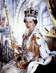
Named after Queen Elizabeth and built in the year of her coronation in 1953.
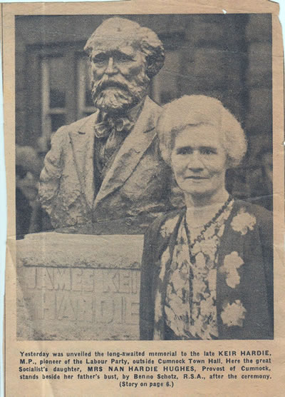
Built in the early 1950's and named after Emrys Hughes, Keir Hardie’s son-in-law who married Nan Hardie. Emrys was a journalist and editor of the Socialist journal Forward. Hughes stood in the 1946 South Ayrshire by-election and was elected as the constituency's MP, and re-elected in the general elections of 1950, 1951, 1955, 1959, 1964, and 1966. A left-winger, he was frequently at odds with the leadership of the Labour Party and twice had the whip withdrawn, between November 1954 and April 1955 (over German rearmament), and between March 1961 and May 1963 (over nuclear weapons). He was Provost of Cumnock from 1934-1935 and a member of the Town Council from 1927-1947.
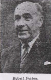
Built in the early 1950's and named after Robert Forbes, Burgh Surveyor and Sanitary Inspector, who came from Buckie to Cumnock as a fully qualified applicant with a certificate in Sanitary Sciences. He served the town for 41 years, from 1915 until 1956. After he died in 1963, he could have been named the “Architect of Cumnock”, as he had planned and built hundreds of the town’s houses.
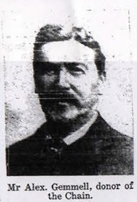
Built in 1924 and named after Alexander Gemmell who was a local benefactor at the beginning of the 20th century. He was a native of Cumnock where he worked in the Royal Bank. He moved eventually to Bradford and to Barclay’s Bank where he held an important position. In 1916 he noted the 50th anniversary of the burgh by presenting a Provost’s Chain currently on view in the Baird Institute.
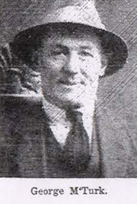
Built in the late 1960's adjacent to the New Cumnock Cemetery in Glaisnock Street. Named after George McTurk, who began his public service in 1894 as a member of a miner’s committee during a strike. Thereafter he served on local public authorities for 43 years. He joined Cumnock District Council in 1923 and was chairman for 9 years. For over 33 years he was on the County Council and was acclaimed for his long service and efforts at his retiral presentation in Cumnock Town Hall on 1st June 1951. George McTurk was awarded the OBE in the Coronation Honours List published in July 1953.
To be completed.
Named after the Glaisnock Water.
Named after the Glaisnock Water.
 Opened in the late 18th century and named after the Glaisnock Water. The Gorbals bridge was built here in 1775. This is the other main street in the town and in days gone bye used to contain many of the town shops and bars.
Named after the Glebe lands belonging to the Old Established Church in the Square.
To be completed.
Named after Glengyron Farm and Pit.
To be completed.
To be completed.
To be completed.
To be completed.
Built around 1924 and named after the first chairman of the Parish Council James Gray, a coalmaster, who served from 1877 until his death on 25th February 1904 at the age of 81.
This area lies just to the east of Glaisnock Street and south of the bend in the Glaisnock Water. Literally it means "the top of the green slope". It may have been an early burial ground for plague victims. Cumnock Pottery was established here in 1792.
To be completed.
Named after the Town Hall.
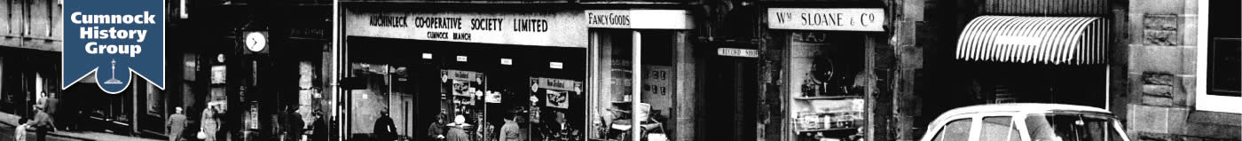
Hamilton Place sits just off Cumnock Square opposite Greenmill Primary School at the bottom of the Barrhill Road. This was originally part of manse Lane. The first shops were opened in 1904 to replace a row of thatched cottages. The first shops were owned by John Goldie, draper; John Andrew, chemist; Miss Grace Samson, draper; Thomas McCaughie, barber; and Hugh Black, solicitor. Most of these shops were later purchased by the Auchinleck Co-operative Society and converted into their main shop in Cumnock. The Co-operative modernised the premises in 1956 adding a second floor to the buildings.
To be completed.
To be completed.
To be completed.
To be completed.
Built in 1932. In the Cumnock Town Council Minutes for 1931-33 the housing scheme is referred to as the “East Side of Glaisnock Street” – but in the minutes dated 10th July 1933 the following information is minuted :-
The Council considered the names for the streets at the East Side of Glaisnock Street Housing Scheme. Police Judge NEIL moved, seconded by Councillor Holland, that the scheme be called Viaduct Terrace. Provost Carruthers moved as an amendment, seconded by Councillor Hughes, that it be called Herdston Place. Provost Carruthers, Bailie Borland and Councillor Hughes (3) voted for the amendment and Police Judges Neil and McCall and Councillor Holland (3) for the motion. Provost Carruthers gave his casting vote for the amendment which was declared carried.
Unfortunately, there is no reason given for the choice of name in the Town Council minutes or in the Cumnock Chronicle of 14th July 1933.
To be completed.
To be completed.
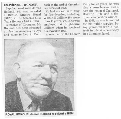
Built in 1954 and named after James Holland, a miner who was the 21st Provost of Cumnock 1947-1954. He also served for over 27 years on the town Council from 1932-35 and 1937-62.
To be completed.
To be completed.
To be completed.
To be completed.
To be completed.
By William Findlay
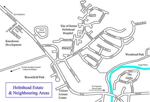
The name Holmhead, attached to a range of buildings, appears on maps of the 1850s on Auchinleck Road, part of the site is now occupied by Keir Hardie's house Lochnorris. In the later 19th century, the name now is applied to the area north of Auchinleck Road. The name is later applied to the hospital, built in 1898, to the west of the original location between Broomfield and Underwood farms, north of Auchinleck Road. The hospital road followed an existing road, which left Auchinleck Road at right angles past a small curling pond and diverged to the left at the top of the pond, this became known as Hospital Road, the lower part being Holmhead Road.
By the 1950s the area on either side of the Holmhead and Hospital Roads was marked as Holmhead on the maps of the period. House building in the area began in the early 60s; initially people had houses built privately for them at the lower end of the road. Local Builders David King & Son bought the upper part of the land, mostly to the east of Holmhead Road but including a strip of land on the west side. The King family built houses on Holmhead Estate for several decades, extending Holmhead Road to the North and built new roads to the East and covered the area with high quality houses. As the houses increased the council of the day revised the lower part of Holmhead Road, swinging it to the west to increase the visibility of vehicles joining Auchinleck road, the lower part of the original road was turned into a footpath.
To be completed.
See Holmhead.
To be completed.
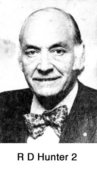
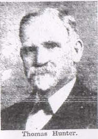 Built in the late 1980's. The name Hunter has been significant in Cumnock for many years. Thomas Hunter, Seed Grain and Cheese Merchant was the 6th Provost from 1893-1896 and Council member from 1878-1895.
His son Robert Dalglish Hunter was an agent of the Commercial Bank and a local solicitor. He became Town Clerk in 1924 and served the town in that capacity until his death in 1941. He was succeeded by his son, also R D Hunter, who had assisted his father from 1936. R D Hunter (2) was interested in sports, music, the arts and had a long association with the Boy Scout movement. Through his interests he played an important part in the cultural development of Cumnock. He was awarded an MBE in 1960. His son R D Hunter (3) was also a prominent local solicitor.
the Brae leading from Barrhill Road down to Townhead Street past where the old town jail was situated. It comes out at the bottom of the Strand.
To be completed.
To be completed.
Leading down from Barrhill Road to Townhead Street this thoroughfare was built in 1908 on land belonging to the John Baird Trustees. Named after John Baird, Architect and Draper, who In his will made a bequest that his estate be used to provide a public building in Cumnock which would contain a museum, recreation and reading rooms on the land owned by him in Lugar Street, known as Baird`s Place. The Baird Institute was opened on March 2nd, 1891.
To be completed.
Built in 1936 just off the Barrhill Road and named after James Keir Hardie the founder of the Independent Labour Party and the first Labour Member of Parliament. Keir Hardie lived in the Barrhill with his young family in in a two roomed cottage until he built Lochnorris in Auchinleck Road where he lived until his earth.
To be completed.
Named after the local builder David King.
Named after Provost John King.
To be completed.
This street, in the Knockroon Development, is called after a poem by Robert Burns. It was named after the disturbances that were taking place in the Church of Scotland in the later eighteenth century. The Cumnock minister James Young is referred to as Jamie Goose, some neighbouring ministers were also referred to.
To be completed.
To be completed.
Built around 1924 Latta Crescent was named after Sir John Latta who was born in Old Cumnock and gained his wealth through his shipping company.
Built in 1956 and linked Elizabeth Crescent and Drumbrochan Road.
Built 1980's and named after Robert Lorimer (Bertie) who was first appointed Burgh Treasurer in 1930. He was also Burgh Prosecutor and became Treasurer of Cumnock Municipal Bank in 1947. He was factor of the town’s housing in his capacity as Town Chamberlain and served the community until his retiral around 1970.
To be completed.
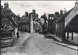 Lugar Street is literally the road over the Lugar Water, and the Stepends Bridge crossing the Lugar marked the old boundary with Auchinleck Parish. Much of the street was demolished to make better access for traffic going up the Barrhill.
Lugar Street was the birthplace of John Baird - who left money to build the Baird Institute.
Built around 1936 and named after Allan McCall was a long serving member of the Council between 1912 and 1946, serving as Provost from 1925 to 1928. In his non-political life he was a fruit merchant and a founder shareholder of the Cumnock Municipal Bank. The shareholders and directors of the bank were unpaid, all the profits of the bank being passed to the Town Council.
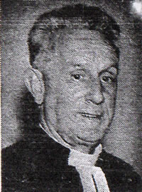
Built in the 1970s and named after the Rev John Douglas McClymont who was ordained as assistant and successor to John Spence Robertson 1927 and served to Established Church in the square until the early 70s.
Built in the 1950's, McDonald Street Drive is situated in the Glebe, the old grounds belonging to the church. The Glebe was purchased by the Town Council in the early 1950’s and all the street were all named after former local ministers. Named after the Rev J F McDonald who was the first Minister of St Andrew’s United Free Church in Glaisnock Street from 1929-1931.
To be completed.
 Built in the early 1950's along with other streets in the area when the Town Council purchased the Shankston Bing site. Named after Dr James McQueen, a local doctor who served the local community from 1901 until he retired in 1947.
To be completed.
To be completed.
A now unused Street that led from the Established Church in the Square to the Manse in Robertson Avenue.
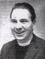
 Built in late 1970's and named after Father Martin Meagher (pronounced Marr) who was a quiet, dignified man, well thought of by Catholics and non-Catholics alike. He served as priest at St John’s Church – firstly on foot, then by horse and trap and latterly by car – from 1906 to 1936. He became a Canon, but declining health saw him transferred to a less demanding charge in Irvine. He died two years later.
To be completed.
Built around 1936 Michie Street was named after the Provost of Renfrew who was arbiter in the inquiry regarding compulsory purchase of land involving a dispute between the Town Council and the Marquis of Bute.
To be completed.
To be completed.
The eastern end of Barrhill Road leads to Muirkirk.
To be completed.
Named after Nan Hardie Hughes, daughter of James Keir Hardie MP and wife of Emrys Hughes MP. She was also Provost of Cumnock 1935-47. Nan also served on the Town Council from 1933-1947 ans was instrumental in realising the plans for the open air swimming pool in the Woodroad Park.
Named after Netherthird Farm.
Named after Netherthird Farm.
 Named after the bridge across the Glaisnock Water at the Dubb. This old street connects Ayr Road with the Tanyard. Cotton weaving was concentrated along this street and also at Townhead.
To be completed.
Built in the late 1970's and named after Patrick Finn who was a local Justice of the Peace and father of Provost Tom Finn.
To be completed.
To be completed.
The Cumnock Pottery, established here in 1792 and in business until 1920, was on the east side of the road. Pottery Row is now part of Glaisnock Street.
Richmond Terrace was named after James Richmond, a mason and builder and the only person to hold the Provostship more than once. He was Provost three times.
To be completed.
An old road that used to begin at Rigg Toll cottage on Auchinleck Road and go past the Rigg farm into Lugar down the Peesweep Brae.
To be completed.
Robbiesland Drive leaves Holmhead Road at right angles and goes east to meet with Oakbank Drive and then swings to the North, it was named after Robbie King, the son of David King a local builder. He continued his father's work but died in middle age. The third generation of the family continued the work.
Built in the 1950's, Robertson Avenue is situated in the Glebe, the old grounds belonging to the church. The Glebe was purchased by the Town Council in the early 1950’s and all the street were all named after former local ministers. The Rev John Spence Robertson was the Established Church Minister in the Square from 1875-1920’s.
To be completed.
To be completed.
Named after Shankston Farm and Pit.
To be completed.
Named after Skerrington Farm.
Named after Skerrington Farm.
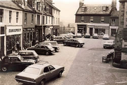 The Square was named after the square graveyard of the Parish Church, which was situated in the centre of the Square. It survives as the centre of town from a very early time. The graveyard was levelled in 1768 to allow access to traffic. The Square was remodelled in the mid 19th century, with the building of a new Parish Church and the demolition of old tenements on the north and east sides.
The Square was also the main market place of Cumnock from at least the mid 18th century until the early 20th century, thus it was the hub of Cumnock from the very early times until it was pedestrianised. Buses, cars, shoppers, commuters and pedestrians used to give it a greater buzz than it currently enjoys.
Parades through the town to celebrate various events in the life of the Bute family were fairly common in Cumnock and often the Square would be decked in bunting and flags to celebrate comings of age, weddings and birthdays.
The road to Auchinleck crossed the Lugar Water in the north-western corner of the burgh at Stepends Ford. A bridge was built here in 1753 and this was replaced by the single arched bridge Lugar bridge in 1864. The origin of the word "stepends" is unclear.
To be completed.
This very old, narrow street connects Townhead Street with Barrhill Road.
Sullivan Way in Holmhead Estate leaves Robbiesland Drive at right angles and goes to the North East. It was named after Matthew Sullivan, the former minister of the Congregational Church in Cumnock. Mr Sullivan was born in Belfast in 1929, became minister of the Cumnock Church in 1955 and retired in 1998. Mr Sullivan died in 2008, a much respected man.
To the west of Bank Lane stood a large open space which by the 18th century had become known as the Tanyard a name retained by a modern thoroughfare. The Tanyard was so called because of the tanning works on the site, which was an ideal one, being beside a ready supply of water (the Lugar). The Lugar Water could also function as a refuse tip for the noxious waste associated with the tanning process.
To be completed.
To be completed.
Previously known as Townfoot and Back Street, Tower Street was named after the Blue Tower Inn, built in 1666 and for many years the principal inn in Cumnock.
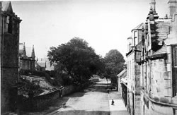
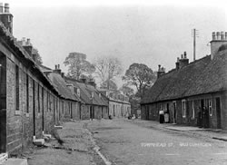 One known as the High Street, Townhead Street means quite simply "head or top of the town". In the olden days it was the main centre in Cumnock for cotton weaving - the houses were single-storey, thatched with two main rooms, one of which held the handloom. Almost every house would have a handloom - some having as many as six. In 1791 Cumnock had 35 handlooms plus 39 muslin weavers and 7 stocking weavers. By 1811 there were 70 muslin weavers and by the 1820s over 120 looms were in operation.
The American Civil War and the introduction of the power loom c1860 led to the decline of the trade and by 1899 only three weavers remained.
The fair in Cumnock may have been held at the east end of Townhead Street, after it was moved from its original site near Stepends Ford
To be completed.
To be completed.
To deal with the problem of bad housing the Town Council made a start around 1914 with a small scheme of houses on John Baird Street.
Burgh of Cumnock Minute Book (CU/1/1/1/4 held at Burns Monument Centre, Kay Park, Kilmarnock).
Burgh Chambers, Town Hall, Cumnock 14th Feb. 1916 at 8 pm .
Councillor Neil moved the following motion of which he had given notice viz.. “That the Council decide to name and number Workmen’s Houses in John Baird Street” which was seconded by Councillor Andrew. Councillor Taylor moved as an amendment that the Council do not name the Houses but merely number them, but as the amendment was not seconded the motion was agreed to. Thereafter Councillor Neil moved that Urbana Terrace be fixed as the name of the Houses which was seconded by Councillor McCall. Bailie Miller proposed as an amendment that the Houses be called John Baird Terrace which was not seconded and Councillor Neil’s motion was agreed to. The Burgh Surveyor was instructed to carry out this motion.
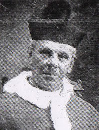
Named after Rev S M Walker, Minister of S. Andrew’s United Free Church 1943-62.
Named after the Rev John Warrick.
Built in the 1950's, Warrick Drive is situated in the Glebe, the old grounds belonging to the church. The Glebe was purchased by the Town Council in the early 1950’s and all the street were all named after former local ministers. Named after Rev John Warrick a local Minister of the Free Church in Ayr Road from 1883-1931. He also wrote The History of Old Cumnock published in 1899.
This street once skirted the northern bank of the Glaisnock Water. A large shopping centre now stands here.
To be completed.
To be completed.
Built around 1936 and named after a Government official who was involved in the inquiry regarding compulsory purchase of land involving a dispute between the Town Council and the Marquis of Bute.


